The Trans Pyrenees cycling tour - one of the mountain bike routes that has become most famous lately in the mountain extreme sports world - is aimed at cyclists who enjoy a challenge. Let the mountains embrace you and make you feel freer than ever with our guide.


STAGE 1: LLANÇÀ – ALBANYA
Dist.: 67,64 Km.; Asc.: 1.637 m.; T. Mov.: 5:47; IBP.: 111AB.
We start our journey at Llançà, which is a small fishing village in the north of the Costa Brava and one of the most popular places chosen by cyclist to begin this adventure. Our route starts by passing through several small towns as Vilamaniscle, Rabós d’Empordà, Espolla, Cantallops, Agullana and Darnius. We next arrive to the Boadella reservoir and then to the Muga valley to finally reach Albanyà.
This is the longest stage of the journey - with almost 70 kilometers - but comfortable, with lots of kilometers of asphalt and no traffic.
STAGE 2: ALBANYA – CAMPRODÓN
Dist.: 57,24 Km.; Asc.: 1.759 m.; T. Mov.: 5:35; IBP.: 132AB.
Leaving behind the Alt Empordà and the Ter basin, we get to the Alta Garrotxa and pass the valleys of Llierca, Castellar and Bac to finally reach the Ter valley.
From Albanyà we leave La Muga to get to the Coll de Riu. In a long descent to Sadernes, we see the Riera de Sant Aniol and Llierca valley until Montagut. Near Castellfollit de la Roca, we begin the long climb up the Castellar valley to the Collet de Colldecarrera and then the Bac valley to the Coll de Pau. Then we arrive to the Ter valley and then Camprodón.
It is a very tough stage - with almost 60 kilometers - in which there are almost 1.800 meters ascent.
STAGE 3: CAMPRODÓN – PLANOLES
Dist.: 62,76 Km.; Asc.: 1.849 m.; T. Mov.. 5:38; IBP.: 119BB.
The first high mountain stage take us to the Coll de la Gralla, first by road to Tregurà and after by a good and wide road to overcome 2000 meters high. After a long descent to Ribes de Freser, we take the road to Queralbs and then the forwarding steep ramps cemented to Vilamanya. A beautiful forest trail connect us with the asphalted road of Corral Blanc to go down to Planoles.
It is one of the most physically demanding stages of this tour, the second with most cruise altitude, with almost 1.900 meters in about 60 kilometers.
STAGE 4: PLANOLES – BAGÀ
Dist.: 57,43 Km.; Asc.: 1.698 m.; T. Mov.: 5:21; IBP.: 128AB.
We ascend the Rigard valley to the Collada de Toses from where we cross the slopes of the La Molina and Masella ski resorts. After crossing the Coll de Pall, we descend the Gréixer valley inside the Cadí-Moixeró Natural Park, in Berguedà.
From Planoles, we pass Planès, Fornells de la Muntanya and Toses to the Collada de Toses and Collada del Pedrò. Around La Molina’s slopes, we ascend to the Cap de Costa Rasa to descend by the Torrent Negre to get to Cap de Costa Rasa. Before getting to Masella, we start the ascending by the slopes of Tossa d’Alp to Coll de Pall. Then we descend and get to Bagà.
STAGE 5: BAGÀ – EL PLA DE SANT TIRS
Dist.: 68,00 Km.; Asc.: 1.671 m.; T. Mov.: 6:21; IBP.: 120AB.
Starting from the Llobregat valley, in the Berguedà, we get to the Cadí-Moixeró Natural Park, where we cross the southern slope of the Serra del Cadí. From Pedraforca’s north face, we crowned the Coll del Torn and from the El Collel we start the long descent that will take us through the valleys of La Vansa i Tuixent. From the Alt Urgell, we climb the Coll d’Arnat to finally descend to the Valley of Segre.
Then we descend along the river Josa to Tuixent and then ascend to Coll d'Arnat. We can only go down, through Castellà of Tost to the Valley of Segre route between Lleida and Andorra, where he finished the stage in Pla de Sant Tirs.
It is a hard stage, the longest crossing with almost 70 kilometers and a significant cumulative altitude of 1.700 meters.
STAGE 6: PLA DE SANT TIRS – LLAVORSÍ
Dist.: 58,57 Km.; Asc.: 1.314 m.; T. Mov.: 5:04; IBP.: 101AB.
Starting from the Segre valley, in the Alt Urgell, we ascend to Sant Joan de l'Erm to to descend to the Pallars Sobirà along the Santa Magdalena valley at the Noguera Pallaressa.
From the Pla de Sant Tirs we get to Noves de Segre, to trace the Pallerols valley, passing Argestues, Cassovall and Pallerols del Cantó, where we cross the Port del Cantó’s road. Then from the Natural Parc de l'Alt Pirineu, and after passing the Coll de Leix, we arrive to Sant Joan de l'Erm, starting the long descent that, surrounding the Pic de L'Orri by the Santa Magdalena valley and through Montenartró, will take us to the bottom of the Noguera Pallaresa valley, ending in Llavorsí.
It is one of the most affordable stage, less than 60 kilometers and 1.300 meters of ascent, which runs along tracks without any special difficulty and with many kilometers of asphalt.
STAGE 7: LLAVORSÍ – TORRE DE CABDELLA
Dist.: 50,06 Km.; Asc.: 1.410 m.; T. Mov.; 4:35; IBP.: 107AA.
From the Noguera Pallaresa we ascend through the Baiasca valley to the Coll de Rat, where we surround the Montsent de Pallars to the Coll del Triador, to after descend to the Vall Fosca in Pallars Jussa.
We next leave behind the Noguera Pallaresa and continue ascending to the Quatrepins refuge. After getting into the Coll de la Portella we cross the slopes of the Llessui’s ski resort and we reach the Coll del Triador. Here begins a dizzying descent to Espui, at the bottom of the Fosca valley, ending at the Cabdella tower.
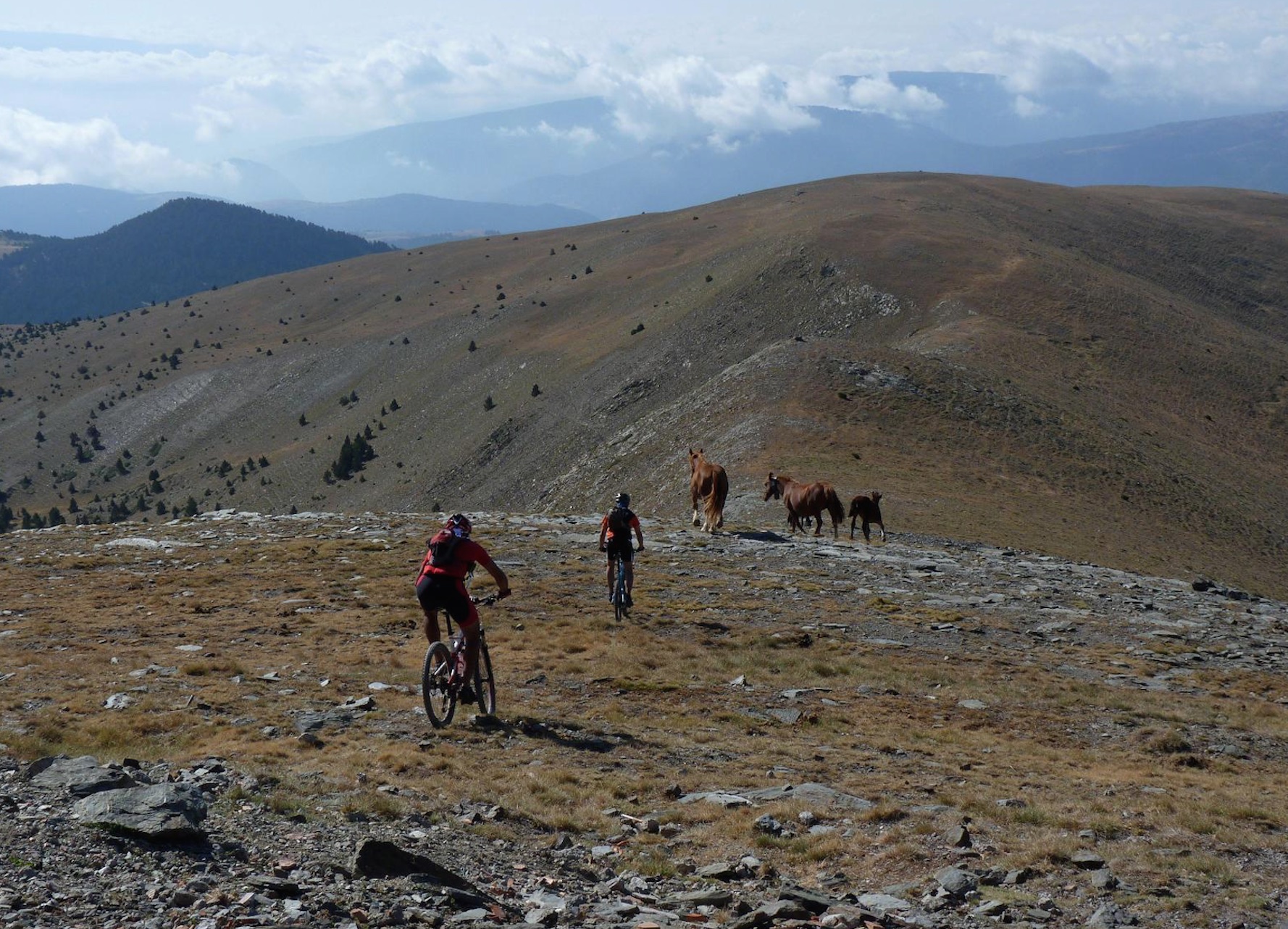
It is one of the most important stages of this journey, with the ascend to Coll de la Portella and cycling almost 25 kilometers above two thousand meters, in a totally Apline environment.
STAGE 8: TORRE DE CABDELLA – PONT DE SUERT
Dist.: 50,06 Km.; Asc.: 1.410 m.; T. Mov.; 4:35; IBP.: 107AA.
It is the middle of the journey and the last day in Catalonia. We leave behind the Pallars Jussa and cross the valleys of La Valiri, Erta, Malpas and Raons, to end at the Noguera Ribagorçana, in the Alta Ribagorça.
From the Cabdella tower, we leave the Vall Fosca to ascend to the Coll d’Oli descending to the La Valiri valley to the Mola d’Amunt. We arrive to Sentis and pass Erta and Sas, two little villages. After a long descend, we reach Malpàs. There is only left to descend from Gotarta to the Pont de Suert, near the Noguera Ribagorçana.
It is a short stage, with only 50 kilometers in which we have to overcome a drop accumulating about 1.400 meters of altitude.
STAGE 9: PONT DE SUERT – CAMPO
Dist.: 57,75 Km.; Asc.: 1.197 m.; T. Mov.: 4:58; IBP.: 102AB.
First day in Aragón where we start the second part of they journey. We leave the Alta Ribagorça in Catalonia to get into the Ribagorça in Aragón. From the Pont the Suert we pass the Barranco de Cirés to reach Bonansa, from where we descend to the Alto de Bonansa.
After a short descend, we leave the Isabena river to pass the Barranco de Espés until we reach the Tozal de Selvaplana. With amazingly beautiful views of the Macizo del Posets in the north face, we start the long descend that take us around the Barranco de Gabás to Seira, in the Ésera valley. We just have to keep cycling by the road next to the river to Campo, with the Turbón in the east and the Cotiella in the north.
Long stage, with almost 60 kilometers, without much accumulated slope, approximately 1.200 meters of ascent, which is hardened by many kilometers by stony roads and bad firm because of its abandonment.
STAGE 10: CAMPO – NERÍN
Dist.: 55,72 Km.; Asc.: 1.913 m.; T. Mov.: 5:28; IBP.: 138AB.
We leave the Ésera valley and the Ribagorza to cross the valleys that separe the Cotiella and Peña Montañesa. Already in Sobrarbe, we pass the Anisclo canyon, that take us into the Ordesa National Park.
From Campo, along the Ésera river, we cross the south of the Cotiella side to the Collado Cullibert. After passing under the cliffs of Peña Montañesa, we reach La Collada from where we descend to Laspuña, at the bottom of the Cinca valley. The small road that runs through the Vió valley take us to Nerín.
This is a very hard stage, with many meters of ascent - with nearly 2.000 meters accumulated - in just 55 kilometers.
STAGE 11: NERÍN – FISCAL
Dist.: 49,52 Km.; Asc.: 1.074 m.; T. Mov.: 3:53; IBP.: 71BB.
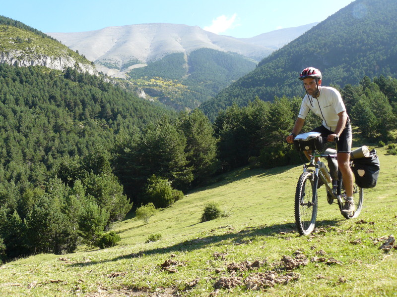
We ascend from the Vió valley to the Sierra de las Cutas, magnificent view of the Ordesa National Park peaks. After cycling during many kilometers above 2.000 meters, just on the edge of Ordesa National Park and Monte Perdido, we descend to Torla to end the stage following the Ara River valley to Fiscal.
Short stage, due to its low mileage, with less than 50 kilometers, and easy, where we only descend about 1.000 meters of altitude.
STAGE 12: FISCAL – SENEGÜÉ
Dist.: 50,95 Km.; Asc.: 1.188 m.; T. Mov.: 5:18; IBP.: 89AB.
We leave behind the Sobarbe to cycle around the Peña Oturia’s slopes, one of the best viewpoints of the central Pyrenees.
From Fiscal we begin the long ascend to Peña Orutia and we reach the Collado de Santa Orosia. After that, we descend by the Oliván canyon to the Gállego river to finally reach Senegüe.
It is an easy stage, with about 50 kilometers and 1.200 meters of ascent, which takes paces mainly in comfortable roads, although we find stony areas.
STAGE 13: SENEGÜÉ – ARAGÜÉS DEL PUERTO
Dist.: 58,70 Km.; Asc.: 1.515 m.; T. Mov.: 5:01; IBP.: 116AB.
It is time to cycle around the western valleys of the Aragonese Pyrenees. From Senegüé, along with the Aragón river, we go to Larrés where we cross the Acumuer valley. We next leave it behind to descend to Pueyo de Escués, highlight of the stage and great viewpoint of the valleys and Peña Telera’s peaks.
Already in the Jacetania we start the long descend through the Garcipollera valley, that take us to Castiello de Jaca on the banks of Aragón river. After a few kilometers around the Aragón valley, we leave in the north the Canfranc valley and La Collarada, to cross the valleys of Borau and Aísa under the Sierra de Aísa’s peaks, to finally reach Aragüés, the highest elevation between the Somport port and the Cantabrian.
Even though it has 60 kilometers and 1.500 meters of ascent, it is an easy stage that mostly runs along roads without any difficulty and no traffic.
STAGE 14: ARAGÜÉS DEL PUERTO – ISABA
Dist.: 52,99 Km.; Asc.: 1.336 m.; T. Mov.: 4:57; IBP.: 109AA.
We cross the last western valleys of the Aragonese Pyrenees: Anso and Hecho, to finish at the Roncal valley (first one in the Navarre Pyrenees).
From Aragüés valley we cross Urdués to descend to the Hecho valley. After reaching the Collada de los Arrieros we change the valley to pass Ansó, from where we ascend to the Puerto de los Navarros. Already in Navarra, a long descend take us by the Barranco Belabarze to Isaba, in the Roncal valley.
Although this stage only have about 50 kilometers and 1.300 meters accumulated, it is really hard and possibly one of the most difficult crossing because of the abandoned roads with terrible firm.
STAGE 15: ISABA – RONCESVALLES
Dist.: 73,40 Km.; Asc.: 1.468 m.; T. Mov.: 5:51; IBP.: 105AB.
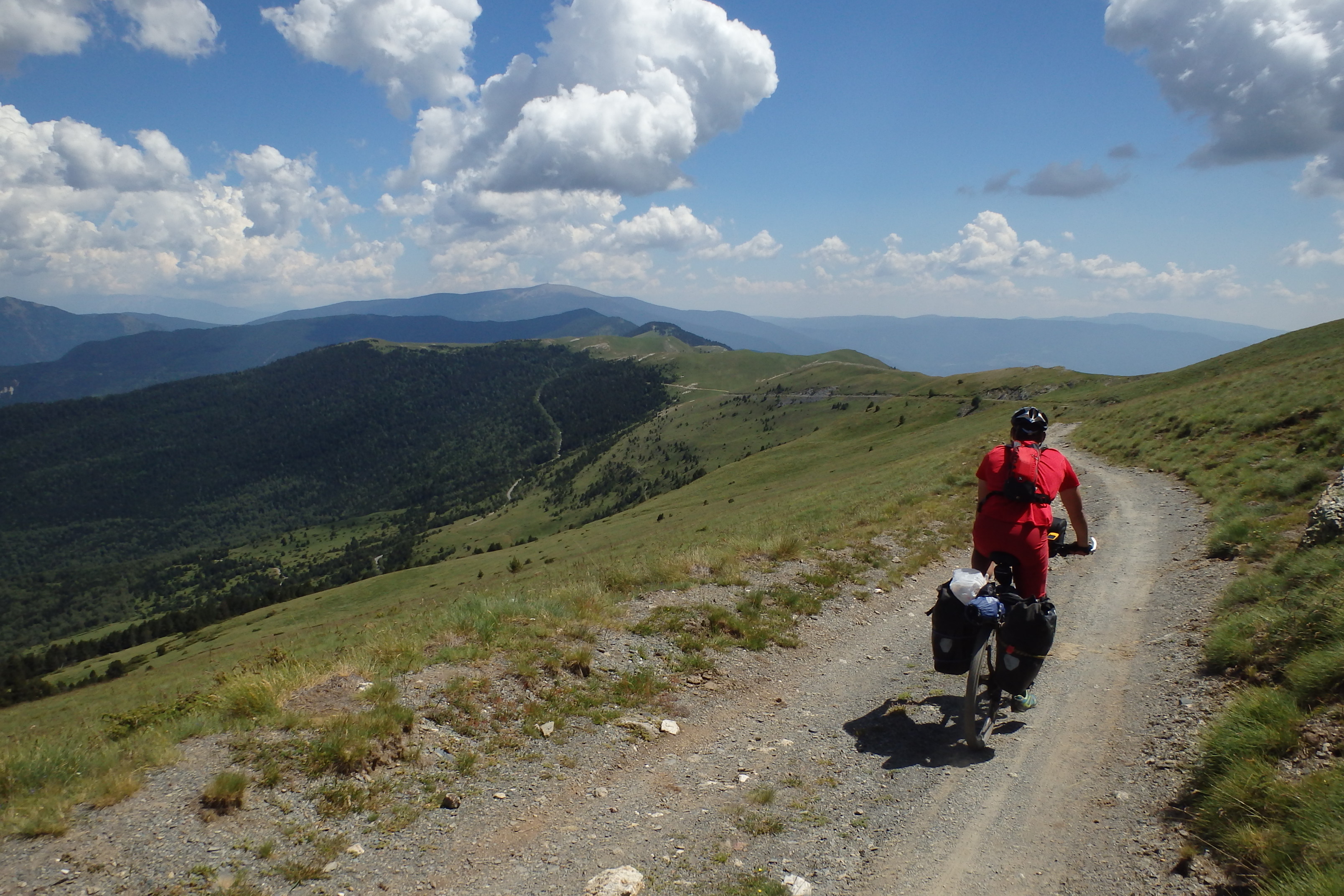
Already in the Navarre Pyrenees’ valleys, we get into the Salazar valley from where we cross one of its most emblematic natural areas: Selva de Irati, to continue around the Aezkoa valley, and end up at Roncesvalles — the Camino de Santiago’s starting point.
This stage is affordable as the roads are very comfortable even though it is the longest of all the journey accumulating almost 1.500 meters of ascent.
STAGE 16: RONCESVALLES – ETXALAR
Dist.: 68,96 Km.; Asc.: 1.610 m.; T. Mov.: 5:33; IBP.: 154AB.
By the Navarre Pyrenees we go through the top of the Baztán valley from where we cross between the mountains of Legate and Alkurruntz to access to the Biadosa valley.
From Roncesvalles we ascend to the Collado Lindus from where we start a long descent around the Hayra valley until crossing the Nive de Aldudes. Already in the Baztán valley, we leave in the south the Señorío de Bertiz and we next ascend to Bagordi. After crossing Also and Orizki, we reach Etxalar.
It is a very demanding stage, with about 1.600 meters of descend and almost 70 kilometers — one of the longest of the journey.
STAGE 17: ETXALAR – HONDARRIBIA — IRÚN
Dist.: 49,53 Km.; Asc.: 1.031 m.; T. Mov.: 4:28; IBP.: 112AA.
On the last foothills of the Pyrenees, next to the French border, we cross the head of the valleys Etxalar and Bera de Bidasoa to finally descend to the Bidasoa river and end at Hondarribia, next to the flows into the Cantabrian Sea.
From Etxalar, we descend to Collado Lizaieta, at the bottom of the Ibantelli-Labeaga hill. We pass Larun and Intzola valley to reach the Alto de Ibardín. Then we descend from the Col des Poiriers to the Bidasoa river to finally reach Hondarribia, the end of our Trans Pyrenees cycling tour.
Although it is one of the shortest stages of the journey, with less than 50 kilometers, it is hard as it accumulates more than 1.000 meters of ascend in the first 30 kilometers.
WHERE TO SLEEP?